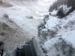
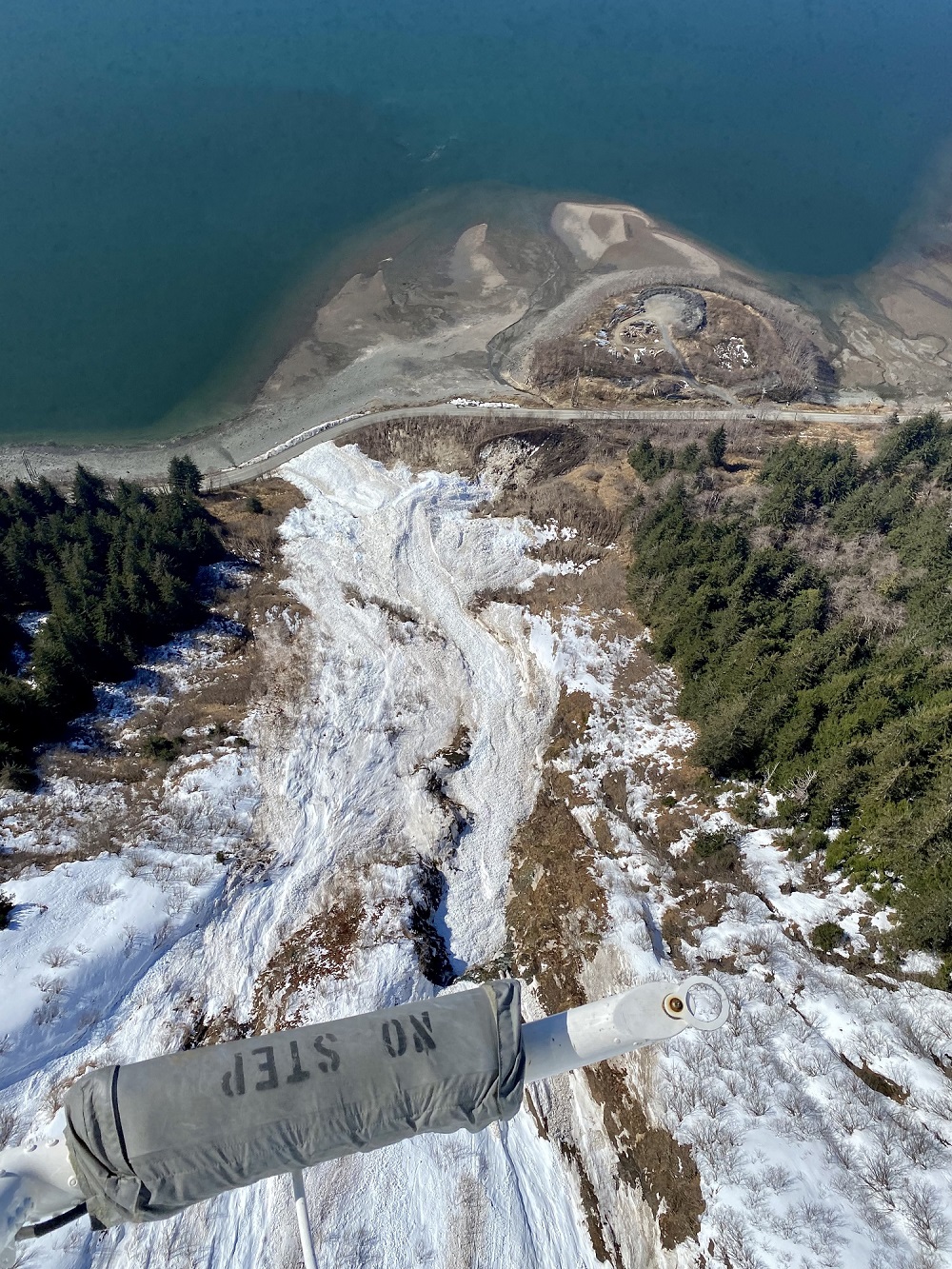
The massive avalanche that released in Keystone Canyon in January of 2014 blocked the Richardson Highway, the only road access to Valdez, for over a week and dammed the Lowe River.
Photo credit: Alaska DOT&PF.
Snow avalanches are a significant cryosphere hazard in mountainous areas around the world. In Alaska, avalanches affect an estimated 30 percent of the state, significantly impacting the natural landscape and gaining the title of the deadliest natural hazard. Avalanche activity in Alaska regularly damages or destroys infrastructure and blocks transportation corridors, impeding access to natural resources and critical public services.
Our snow avalanche research aims to improve understanding of the impacts of avalanches on public safety, infrastructure, landscape change, wildlife, and access to natural resources.
Our research is developed in a co-production setting with other researchers, snow avalanche practitioners, and stakeholder partners and we deliver actionable science that ranges from path-specific avalanche flow dynamics to regional-scale avalanche hazard mapping.
While avalanche event records exist along highway and railroad corridors, avalanche information is sparse in most of Alaska. Detailed avalanche hazard analysis is not possible because baseline snow distribution, meteorological, and avalanche incidence data are lacking due to the state's large, poorly accessible landscape with vast areas of complex terrain. This makes it challenging for avalanche forecasters and resource managers in the state to predict, for instance, how a 300-year event would flow and what assets would be affected, or which slopes could fail under certain extreme weather scenarios.
DGGS's Climate and Cryosphere Hazards Program (CCHP) is developing climatology-based, regional scale snow avalanche hazard maps for Alaska in partnership with collaborators from the Alaska Climate Adaptation Science Center at the University of Alaska Fairbanks and WSL Institute for Snow and Avalanche Research SLF, Switzerland. While less detailed and accurate for individual paths, these regional scale hazard indication maps are based on numerical model simulations over large areas and can provide spatially continuous avalanche hazard information.
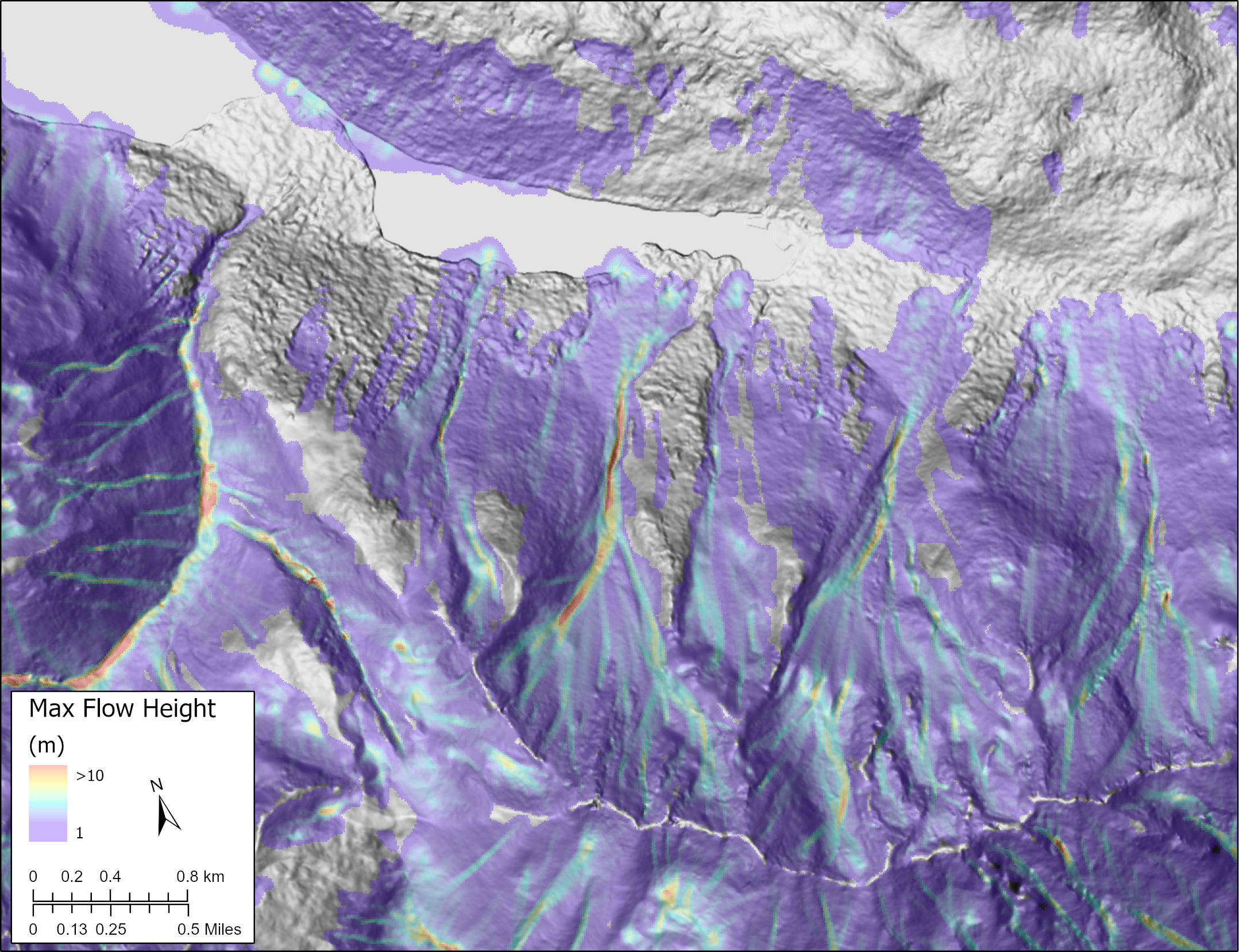
Large-scale snow avalanche simulation of extent and maximum flow height for an extreme snow accumulation scenario in the 1981-2010 climatology for Chilkat Lake, AK. Displacement waves generated by large avalanches threaten homes near the shore of the lake.
As climate warming continues, there is an expectation of an increase in Alaska's vulnerability to snow avalanche hazards for which there is currently limited fundamental knowledge to support adaptation, mitigation, and preparedness efforts. CCHP is working with collaborators from the University of Alaska Fairbanks and WSL Institute for Snow and Avalanche Research SLF, Switzerland on a USGS Alaska Climate Adaptation Science Center-funded project that focuses on quantifying changes in future snow avalanches in Southeast Alaska and understanding the impacts of these changes on natural resources, and people in their natural and built environments.
In the absence of baseline data and detailed avalanche information, we collect our own. CCHP deploys weather stations and uses airborne remote sensing (lidar and photogrammetry) to acquire detailed terrain, snowpack, and avalanche event data. This information is used to model simulations of avalanche runout or reconstruct specific events to gain better understanding of avalanche flow behavior and the impacts on public safety, natural resources, and infrastructure (Rapid Mass Movements - RAMMS; Christen et al., 2010).
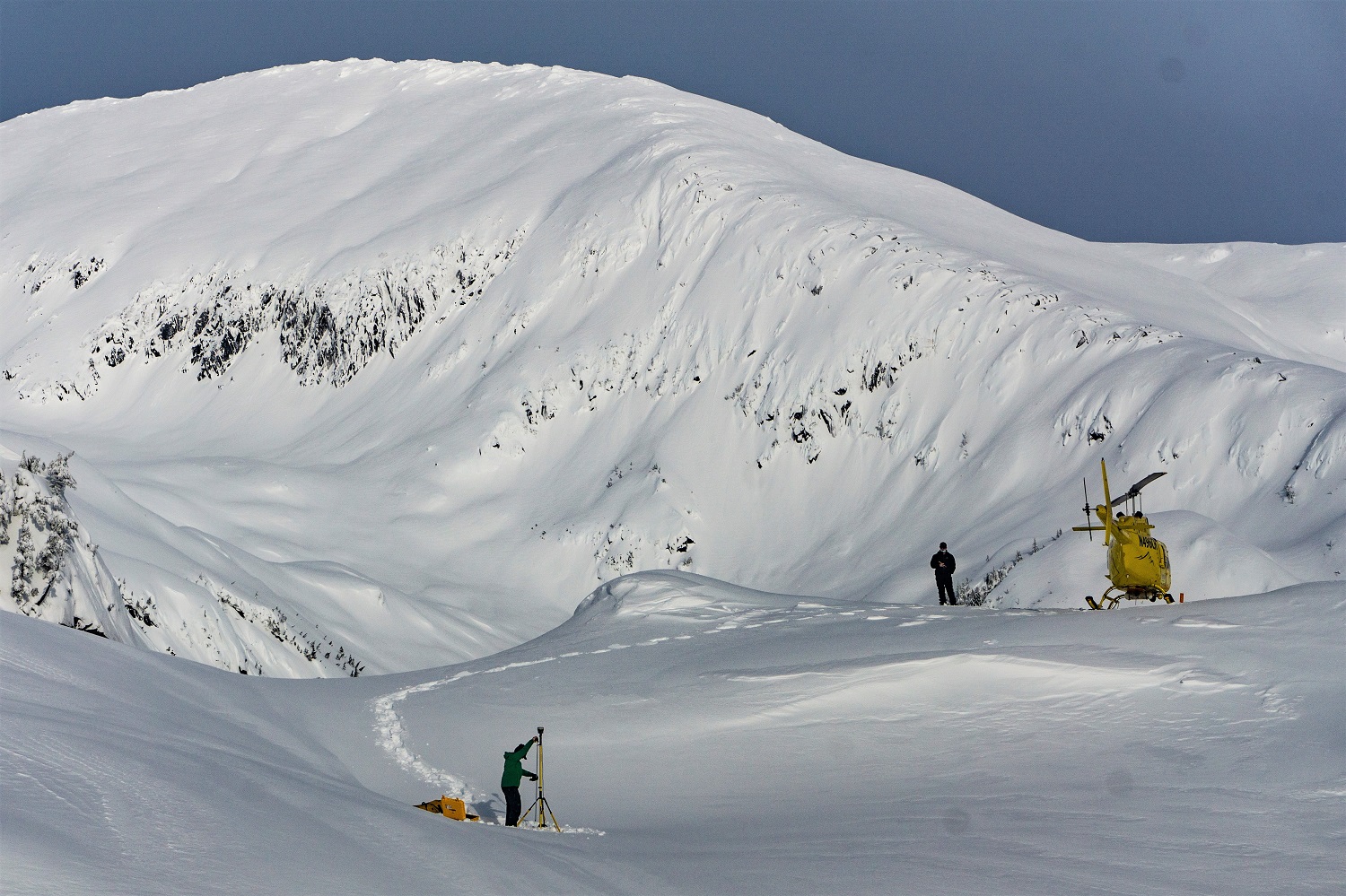
GNSS base station set-up in support of an airborne lidar survey near the Snettisham electrical transmission line, Speel Arm, southeast Alaska.
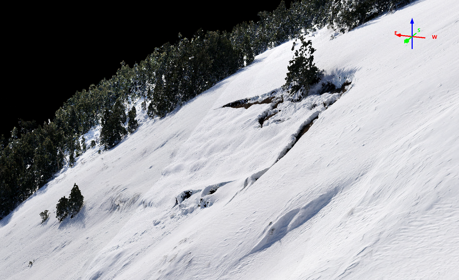
Photogrammetry-derived point cloud showing a glide crack at Kensington Mine, southeast Alaska.
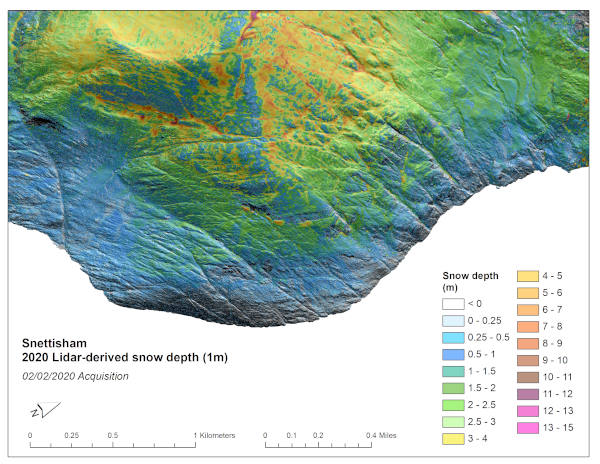
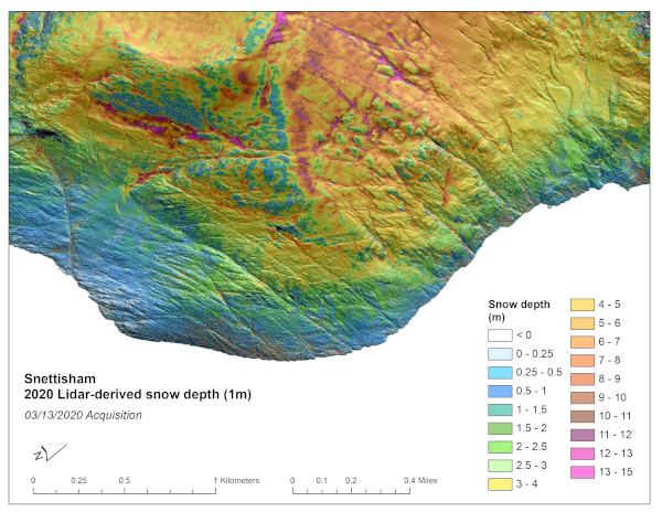
Lidar-derived snow depth distribution along a section of the Snettisham electrical transmission line, Speel Arm, southeast Alaska on February 20, 2020, and March 13, 2020. This slider-enabled image illustrates the effect of snowstorms and wind on snow redistribution between these two acquisition dates.
Post-avalanche mitigation lidar survey at Thane Road, Juneau, southeast Alaska, on April 16, 2021.
This research effort is supported by multiple, diverse partnerships in a co-production framework. Recent collaborators and partners include University of Alaska Fairbanks, University of Alaska Southeast, WSL Institute for Snow and Avalanche Research SLF, Alaska Railroad, Alaska Department of Transportation and Public Facilities, Alaska Department of Fish and Game, USGS, Alaska Energy Light & Power, Kensington Mine, Alaska Avalanche Information Centers, and the cities of Juneau and Sitka.
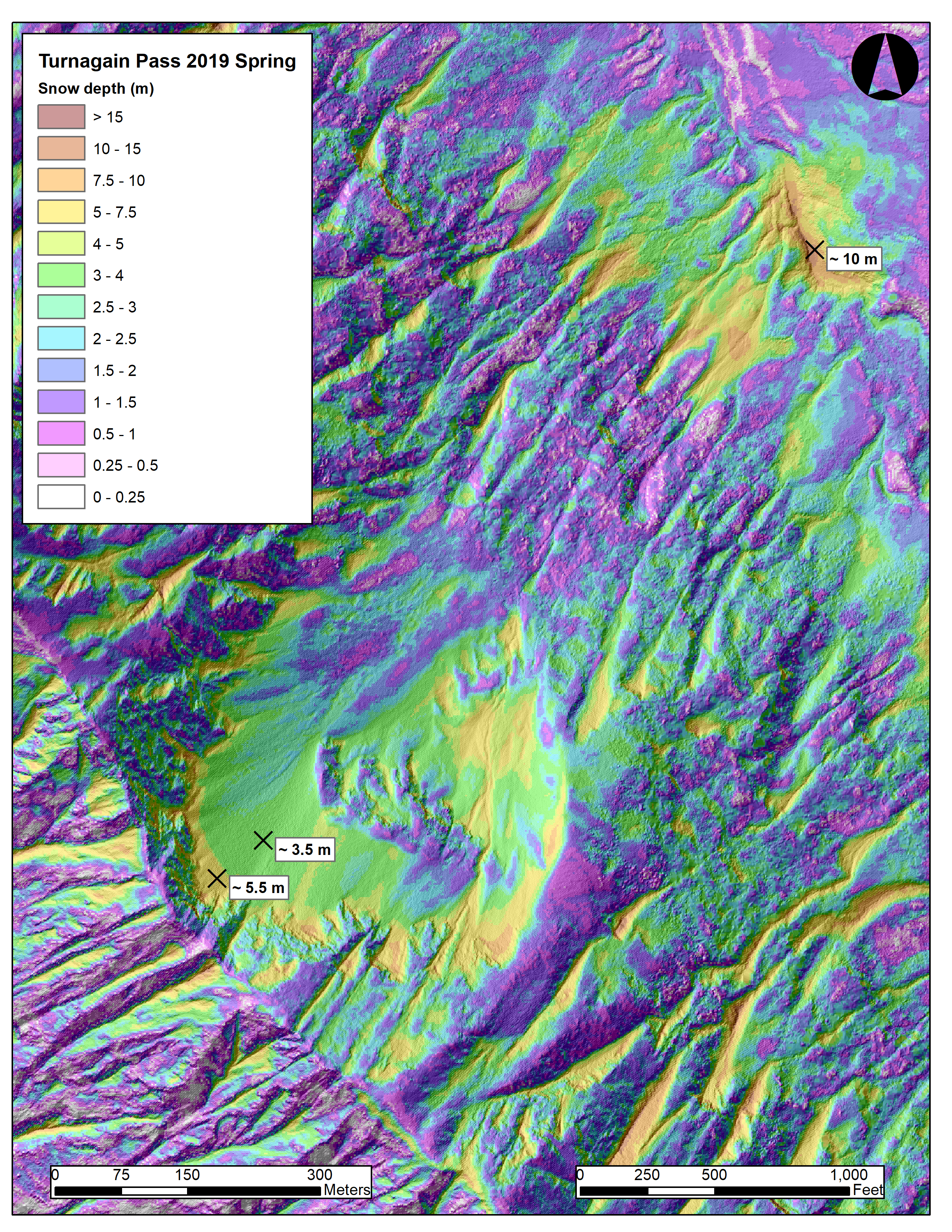
Snow depth distribution on the Tincan slope, Turnagain Pass, southcentral Alaska, on March 28, 2019, showing the avalanche crown and release area on the upper slope and avalanche debris deposited in the valley.
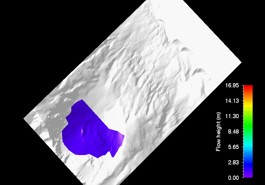
Reconstructed avalanche based on lidar-derived snowpack information on March 28, 2019.
Click image to view animation.
Gabriel J. Wolken, Ph.D.
Climate & Cryosphere Hazards Program
Program Manager
Phone: 907-451-5018
Email: gabriel.wolken@alaska.gov
Katreen Wikstrom Jones, M.Sc.
Climate & Cryosphere Hazards Program
Hydrologist
Phone: 907-451-5006
Email: katreen.wikstromjones@alaska.gov